

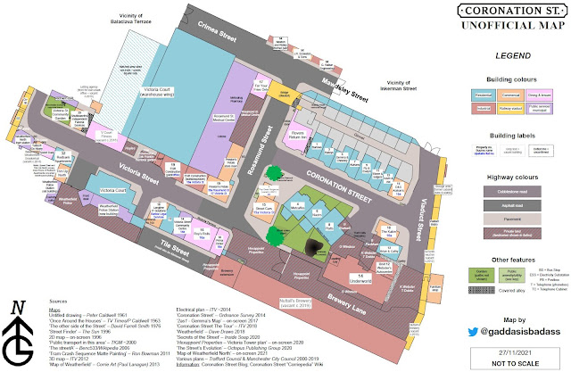
It's nothing new. People have been mapping Coronation Street and its surrounds since the dawn of [Weatherfield] time. Peter Caldwell, a Granada TV designer, started off the hobby as his actual job in 1961. I imagine it wouldn't have even crossed his mind to think that his creative vision is still in our living rooms today... amazing, eh?
I could try and claim that I decided to have a go at making my own map in homage to Caldwell (it coincides almost perfectly to mark the 60th anniversary of the publication of his), but alas, I only just came to this realisation when researching for this blog post. Perhaps deep down I knew. Or maybe I was just feeling cartographically inclined.
Either way, there have been many maps since and I'm sure many more to come. I won't bother mentioning them all as there's well over a dozen (I've listed my sources within the map itself), but some I feel are particularly noteworthy:
David Farrell Smith (1976) – still used as an authoritative point of reference today, I believe.
The Sun (1996) – surprisingly comprehensive!
Benc533 (2006) – a somewhat enigmatic, hand-drawn(?) contribution from another Ben.
Corrie Art/Paul Lanagan (2013) – a wonderfully digitally-drawn version.
Dave Draws (2018) – a doodle map that's up in Underworld!
Not forgetting, of course, the many excellent official maps that have been created by the Corrie team over the years. Oh, and those guys at Ordnance Survey made a reasonable attempt too I suppose 😉
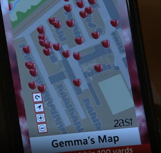
Just for fun, I also used a few on-screen maps to guide me. This one from Gemma's Tinder 2as1 app is my favourite, despite the fact that it shows a seemingly impossible street behind the Medical Centre – with a Bumble 2as1 match hovering there! But who cares... I love this sort of thing:
If you do want to have a gander at my attempt, you can see it in all its glory here. I might even update it at some point. Thanks to @MichaelAdamsUk for reliably informing me that Rosamund Street now continues to the west behind the viaduct (bridge), so I guess we can say goodbye to the illusive Crimea Street for now!
I'll probably post more nerdy stuff like this here and over at @gaddasisbadass if you're a Tweeter.
P.S. If anyone knows of any maps still around that pre-date Caldwell's, I'd love to know!


3 comments:
I love this map. My hubby wants a Corrie map. Can I get a copy anywhere ? Thanks
Where is the hair salon ?
And ...Streetcars.!
Post a Comment